
Google's Geographic Layer
Google Earth has released some new layers that they are calling the Geographic Web. When turned on, these layers display icons where they have relevant, geotagged information to share. The layers include information from Wikipedia, Panoramio, and the Google Earth Community. These layers have been added automatically.
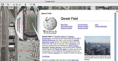
I find the Wikipedia layer especially useful. It displays photos and an excerpt from a geotagged article. The geotagging is the result of the site-wide WikiProject Geographic Coordinates; you can see the the geotags in the top-right corner of Wikipedia pages. This seems to be just a further integration point between Google and Wikipedia. Google already supplies their search (along with Yahoo!) and uses Wikipedia's content for some inline answers.
The Panoramio.com layer is also useful, showing geotagged photos taken by its users. The new, Spain-based photo-sharing site just passed their 100,000 photo mark on December 10th. The site has an emphasis on geotagging photos and maps views. Though fairly sparse, the photos are generally high-quality. Prior to their direct inclusion in Google Earth, they had released a KML feed for their site and received assistance from Keyhole founder/Google Earth GM John Hanke. Getting this attention from Google is definitely a lucky break for the startup!
When I read the news about the new layers my immediate thought was where's Flickr? They've added geotagging, why don't I have a KML feed for my photos, my contacts, tags, or the world's photos? Using Google, I was able to find Metal Toad Media's Flickr Layer that displays all geotagged photos in an area. Each of the red dots in the screenshot represents a Flickr Photo; as you can see from the red-dot fever you can find a Flickr photo almost anywhere.
I communicated with Dan Catt, Flickr employee, Google Maps Hacks contributor and blogger at Geo Bloggers. He pointed out that "Google Earth's network links automatically passes over the current bounding box as a URL parameter to whatever it's connecting to using the parameter bbox=x1,y1,x2,y2. Flickr's search API for geotagged photos take the parameter bbox=x1,y1,x2,y2 to define the bounding box. The only step missing is for either Flickr to output KML natively, or Google Earth to parse geoRSS." Personally I would take either! If Google Earth consumed geoRSS then geotagged blogs could be viewed as well. I hope Google Earth (and the MS browser-based competitor, Spaceland) take these steps.
This is yet another reason to get a location-aware camera (or mod the one you have). Here are some options for you.
tags: web 2.0
| comments: 4
| Sphere It
submit: ![]()
![]()
![]()
![]()
0 TrackBacks
TrackBack URL for this entry: http://blogs.oreilly.com/cgi-bin/mt/mt-t.cgi/5101
Comments: 4
Those are actually pretty cool features. Been using them for a couple of days now and I wonder what'll be next...
Speaking about "geotagging": do you know locr?
locr offers the ideal solution and makes geotagging exceptionally easy. locr uses GoogleMaps with detailed maps and high-resolution satellite images. To geotag your photos just enter address, let locr search, fine-tune the marker, accept position, and done! If you don´t know the exact address simply use drag&drop to set the position.
For automatic geotagging you need a datalog GPS receiver in additon to your digital camera. The GPS receiver data and the digital camera data is then automatically linked together by the locr software. All information will be written into the EXIF header.
Use the "Show in Google Earth" button to view your photos in Google Earth.
With locr you can upload photos with GPS information in them without any further settings. In the standard view, locr shows the photo itself, plus the place it was taken. If you want to know more about the place where the photo was taken, just have at look at the Wikipedia articles which are also automatically assigned to the picture.
Have a look at www.locr.com.
I find those color dots really annoying... but maybe I just have to get used to them.
Note that, when you zoom in far enough, the dots are replaced by proper icons. The Wikipedia one is the same as it was, but the Panoramio icon is a generic camera, and Google Earth Community one is a note. This suggests that Google may add more sources to the Geographic Web layer.
Post A Comment:
STAY CONNECTED
RECENT COMMENTS
- kredi on Google's Geographic Layer: I find those color dots...
- Tom on Google's Geographic Layer: Speaking about "geotagg...
- soeren on Google's Geographic Layer: Those are actually pret...
- Bob King Neverland III on Google's Geographic Layer: Lol, it won't be long u...
RADAR TOPICS
Bob King Neverland III [12.12.06 10:57 AM]
Lol, it won't be long until we get Google Crust, Mantle, and Core.