
Using Turk for GIS
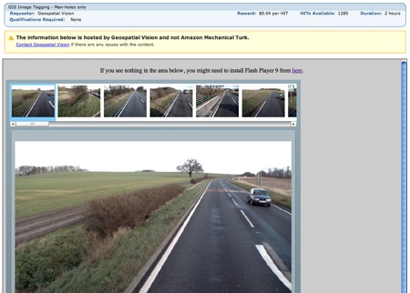
Amazon's Mechanical Turk is now being used to produce GIS data for video. Geospatial Vision is paying a pittance for Turkers to process 50 consecutive images taken from a car - just 3 cents! Using the supplied flash app you mark man-holes, drainage, pedestrian crossing, bollards, and yellow lines. It's an interesting use of Turk, but one that may not be scalable. There are almost 1500 HITs or Human Intelligence Tasks (example) available, but that would process under an hour of footage. I wonder if this is being used as training data. (Note: Amazon was the first to use Turk to process GIS data with A9).
I found out about this HIT via an article on Read/Write Web where Richard MacManus pointed out that there is no killer app for Turkers. That Turkers lament the lack of consistently engaging work. This does seem to be true. However, I don't think that it can be argued that it's not one of the most interesting and widely-applicable Web 2.0 Services out there. A great breadth of applications have been built with M Turks' APIs and people. On Radar alone, we've written about the innovative Sheep market, the new name that tune service, and the Amazon owned categorization and question and answer service. Other applications include transcribing audio and fixing product lookups. MTurk may not have found it's killer app, but it certainly seems to have found its various niches.
[from OpenGeoData via Read/Write Web]
tags:
| comments: 0
| Sphere It
submit: ![]()
![]()
![]()
![]()
0 TrackBacks
TrackBack URL for this entry: http://orm3.managed.sonic.net/mt/mt-tb.cgi/1689
Comments: 0
Post A Comment:
Radar RSS feed

