GeoPress is a plugin that makes it easy to embed locations and maps in a WordPress blog – without having to code! It was previewed last week at FOSS4G and v1.0 was released today at EuroOSCON in Brussels.
As evidenced by the remarkable adoption of geocoding in Flickr (over 4 million photos have been geo-tagged in just over 3 weeks) people want to add this data to their content. GeoPress enables that for a WordPress blog. It allows the user to easily add maps and geo-coded locations to their posts. Blog posts can also be organized by location. Embedded locations and addresses are inserted as microformats and are syndicated out in GeoRSS 1.0 (which was finalized and released last week at FOSS4G).
As with all wordpress plugins drop it in the wp-plugins directory and then activate it from the WordPress web interface. The plugins settings allow you to choose map size, map provider (Google, Yahoo!, or Microsoft), and enable GeoRSS 1.0 (just released last week at FOSS4G). The plugin uses the Yahoo! Geocoder API so you will need to register an Appid with them. If you choose to use Google Maps then you will need to get a key from them. Microsoft does not require any preregistration to use their maps API. Geopress uses Mapstraction, a very cool Javascript library, to handle switching between map providers.
Developers (and adventurous PHP-spelunkers) can add GeoPress-specific functions to their WordPress themes to display the associated map, address or coordinates.
Currently, the plugin is only supported on the WordPress platforms. There have already been requests for it to be ported to other blogging platforms. Currently there is only support for points; support for lines will come in future versions. The GeoPress site has a wiki and the file.
The plugin author, Andrew Turner, blogs at highearthorbit.com. He also works on Mapufacture.com with Mikel Maron, who spoke at Where 2.0 and FOSS4G about GeoRSS. Pay attention to these two; they are working on some great projects in the neogeographer space.
Right now the most obviously useful part of this plugin is the ability to easily add maps and locations to your blog posts. In the future, it will be the GeoRSS output. As the number of GeoRSS feeds grow (Flickr, Upcoming, Platial already have them) there will be more sites like Mapufacture that will consume GeoRSS feeds and the ability to create feed-driven maps will increase in demand. As Andrew puts it in his presentation, “If you build it, they will publish”.
Click through for screenshots.
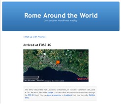
An embedded map in a blog post:
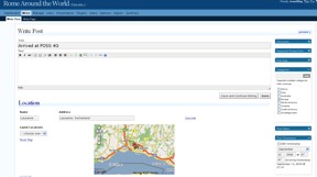
The plugin interface for creating the map:
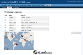
The plugin interface for editing locations: