
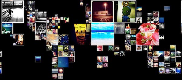
The pictures of a place informs you about that location. They provide context. Bloom’s brand-new Cartagr.am uses Instagram’s new API to do just that. Cartagr.am creates a map out of geolocated images. If you squint you can see the six populated continents above.
Like any good map-based app, Cartagr.am lets you explore at a local level. As you zoom in to an area new photos appear and sizes shift. Unsurprisingly, Austin looks a lot different from Seattle. The images and their relative sizes are selected based on interestingness.
Cartagr.am’s platform shows the Stamen roots of the founders. From their blog we learn that it:
… was written using ModestMap.js for the tile mapping and SimpleGeo for the location services and the labels are the Acetate labels from FortiusOne and Stamen.
The fact that an app this rich is all in JavaScript is just amazing. ModestMap.js allows for broader mobile browser support than a Flash-based mapping framework, and it supports multi-touch for a potential iPad version.
Bloom is a not-yet-funded startup headed up by technology veterans. The co-founders are Ben Cerveny (Frog Design, Ludicorp, and others) , Tom Carden (Stamen Design), Robert Hodgin (Barbarian Group — see some of his beautiful work at Flight 404 ), and Jesper Andersen (Trulia).
They recognize that we are all drowning in a sea of data. Their goal is to make interacting with that data a beautiful and pleasurable experience. The tools they’ll create will (hopefully) be accessible to anyone, regardless of technical skill level.
Cartagr.am is not the only geo-related Instagram app. Instabam will show you photos near you (via instagramers.com)
Cartagr.am is a great visualization tool and it captures the diversity of Instagram photos across the world. However, it’s missing the activity of Instagram, which is is clocking ~6 photos per second. I want to see photos appear and change size as their interestingness score changes.
Tom Carden is speaking at Web 2.0 Expo SF in a session entitled “Data Visualization for Web Designers: You Already Know How to Do This.” Save 20% on Web 2.0 Expo registration with the code WEBSF11RAD.
Where 2.0 — April 19-21 in Santa Clara, Calif. — will features lots of associated sessions, including Raffi Krikorian’s workshop on “Realtime Geo Data.” Save 25% on Where 2.0 registration with the code WHR11RAD.